Europeans believed there must be a great land mass in the south to balance the land mass in the north. It was this belief and the potential for profits that led to the European explorations of Australia but Europeans were not the first to make contact with Australia or its people.
The Makassans
The Makassan people sailed from what is now Indonesia to Northern Australia as early as the 1600s. Their name for this land was Marege. They came to collect trepang (sea cucumber), which they used to trade with the Chinese. The traders usually arrived in northern Australia around December. The arrival of the monsoon winds in April signaled it was time to set sail for the return journey to Indonesia. This trading relationship lasted hundreds of years.
The Torres Strait
In 1606, Luís Vaz de Torres a maritime explorer sailing on a Spanish expedition navigated the strait between New Guinea and Australia. Although he may not have sighted the mainland of Australia, the Torres Strait is named after him.
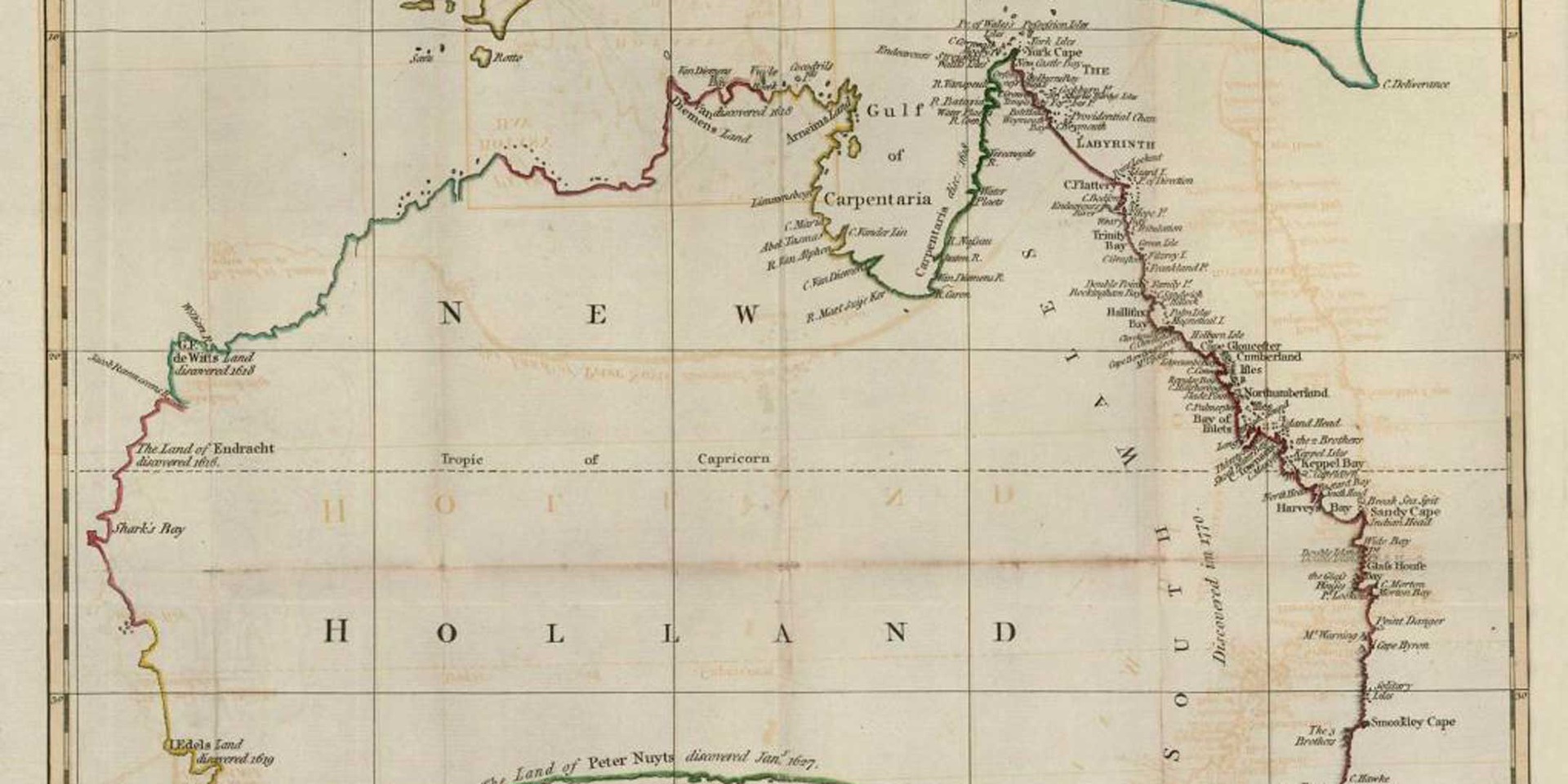
New Holland
In 1642, The Dutch explorer Abel Tasman charted the southern parts of what he named Van Diemen's Land (Tasmania) and then in 1644 charted the north and north-west coast from Cape York right around to North West Cape. At this time this south land was named Hollandia Nova, New Holland. With no prospect of successful or profitable trade, the Dutch completed their explorations of Australia.
The East Coast
The Admiralty instructed Cook to search for the Great Southern Land, the discovery of which ‘will redound greatly to the Honour of this Nation as a Maritime Power, as well as to the Dignity of the Crown of Great Britain, and may tend greatly to the advancement of the Trade and Navigation thereof'. Cook followed instructions and after finding no land south of Tahiti to a latitude of forty degrees sailed west where he charted the north and south islands of New Zealand providing proof that New Zealand was not part of a great southern continent. Cook then sailed west in hopes of finding New Holland to follow its coast northwards for the return to Britain. The East Coast of Australia was sighted in April 1770 and Cook in search of supplies of fresh food and water sailed north until he reached a suitable place to land. The Endeavour stayed 8 days in Kamay/Botany Bay then continued north charting the East Coast of Australia. Charting this coast for the first time, the Endeavour ran into the great Barrier Reef south of Cooktown and was severely damaged. Repairs were made and Cook continued north. Before leaving, Cook took possession of the eastern portion of Australia in the name of King George III under the principle of terra nullius.
The East Coast of Australia had been charted but the question of the existence of a great southern continent had not been answered.
Cook's maps as well as the reports in his and Bank's journals opened the way for the First Fleet and the establishment of the British penal settlement in 1788.
Question: How did Cook's experiences in Australia affect Aboriginal and Torres Strait Islander peoples? What discoveries are still to be made in mapping our world?
Main image: A New Chart of New Holland on which are delineated New South Wales and a Plan of Botany Bay, drawn and engraved by Jno. Andrews. 1787. ANMM Collection 00000368.