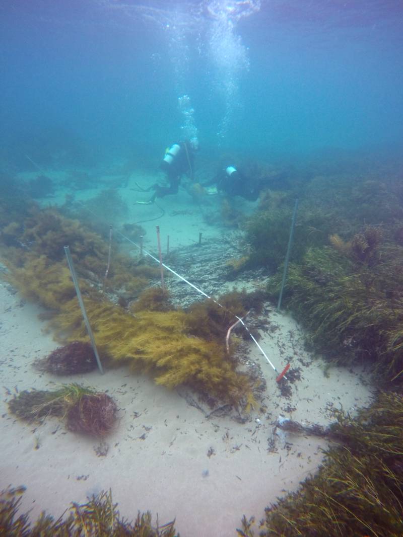
and Kieran Hosty use baseline-offset mapping to record the hull structure in South Australian's bow. Image Tim Zapor")
Header image: James Hunter (left) and Kieran Hosty use baseline-offset mapping to record the hull structure in South Australia's bow. Image Tim Zapor
Nearly 200 years after its loss, the barque South Australian was relocated by a research consortium that included the museum's maritime archaeology team. Dr James Hunter and Kieran Hosty share the story of South Australia's oldest recorded European shipwreck, and the effort to find, document and preserve it.
Shortly after 5 am on 8 December 1837, Captain J B T MacFarlane peered into the grey dawn with a growing sense of dread. From the weather deck of the barque South Australian, he could just make out the lee shore of Rosetta Harbour, a short distance to the north and west. Located along the southern coast of the Fleurieu Peninsula in the fledgling colony of South Australia, Rosetta Harbour was the anchorage for three shore-based whaling stations and the watercraft that supplied and supported them. South Australian was one such vessel, and had been moored in the harbour for about a week as its crew prepared to load the whaling stations’ takings for the season. The harbour was suitable when seas and winds were calm, but completely open to the south and southeast, and susceptible to the worst weather the Southern Ocean could throw at it.
Silentworld Foundation maritime archaeologist Irini Malliaros and Flinders University Master of Maritime Archaeology student Tim Zapor document South Australian's bow section in June 2019. The vessel's stem post and bow cant frames are visible in the foreground. Image James Hunter
'A very heavy gale with a tremendous sea'
MacFarlane now found his vessel at the mercy of a south-easterly gale that steadily increased in fury as the sun rose above the horizon. At 10.05, the chain to South Australian’s starboard bower anchor parted; MacFarlane mustered all hands and ordered them to quickly deploy the barque’s sheet anchor – an action of absolute last resort. This steadied the barque, but the reprieve was brief: at 11 am, a severe squall screamed through the anchorage, followed by another at 2 pm that caused South Australian to ‘labour and pitch very heavy’ at its two remaining anchors.1
The wind and sea state were still increasing three hours later when both anchor cables parted from the strain. Now adrift, South Australian was pushed towards a thin strip of reef that divided Rosetta Harbour from east to west. The barque struck at 5.30 pm, and its rudder was wrenched away as it passed over the reef. Adrift once more, South Australian finally grounded and bilged in shallow water a short distance from shore.
Nearly 200 years later, in April 2018, we were part of a collaborative team comprising maritime archaeologists, museum specialists, students and volunteers from Silentworld Foundation, South Australian Maritime Museum, South Australian Department for Environment and Water, MaP Fund and Flinders University that successfully located South Australian. The discovery is of considerable importance, as the vessel is South Australia’s oldest known European shipwreck. It was also one of the earliest vessels to ferry European settlers to the colony of South Australia, and is currently the only example in the world of a purpose-built postal packet to have been archaeologically investigated.
Postal packet to processing platform
South Australian was launched as Marquess of Salisbury at Falmouth, England, in 1819.2 Originally rigged as a ship, the 236-ton vessel was designated a Falmouth packet, a unique class designed to quickly carry mail between Great Britain and overseas ports within its far-flung empire. Its owner and master, Thomas Baldock, was a former naval officer who had served with distinction in North America during the War of 1812. In 1824, Marquess of Salisbury was purchased by the Royal Navy, renamed HMS Swallow and commissioned as a naval packet. Baldock was reappointed to the Royal Navy the same year and given command of Swallow, then embarked upon a number of transatlantic voyages to North and South America and the Caribbean. While under the command of Baldock’s successor Lt Smyth Griffith in 1834, Swallow was dismasted in Cuban waters during a hurricane and underwent significant repairs in Havana. Two years later, it was decommissioned and sold to the South Australian Company (SAC), a British mercantile enterprise founded in 1835 to establish a colony of free European settlers in what is now South Australia.
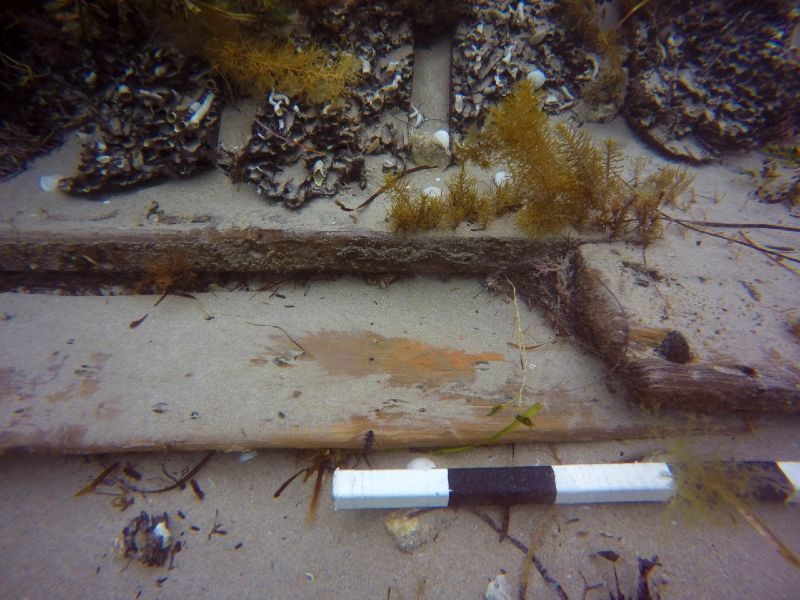
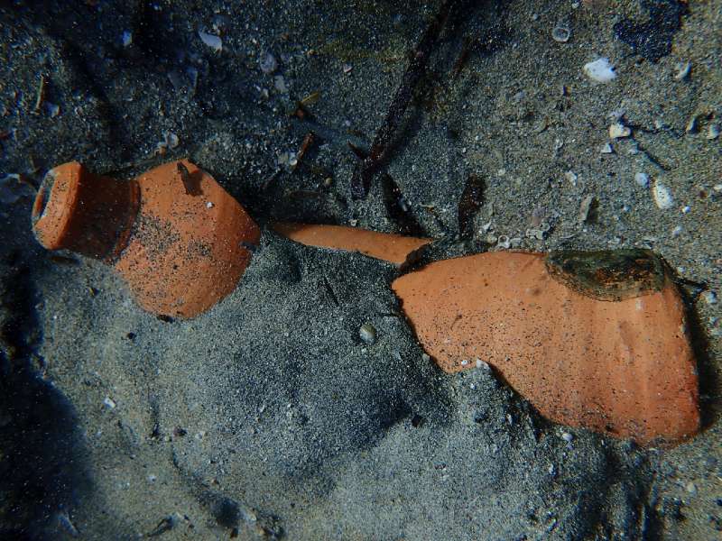
Double planking in the recently-exposed midships section was probably used to repair and reinforce South Australian's ageing exterior hull. Note the higher degree of preservation exhibited by the planks when compared to the worm-eaten frames just above them that have been uncovered for much longer. Image Kieran Hosty
After the SAC acquired Swallow in September 1836, it was re-rigged as a barque and renamed South Australian. The hull was adapted to transport migrants, although the SAC’s ultimate intention was to use the vessel for whaling upon its arrival in the colony. South Australian departed Plymouth in December 1836 under the command of Captain Alexander Allen. Aboard was a contingent of primarily British and German emigrants, including David McLaren (the SAC’s second commercial manager), John and Samuel Germein (credited as the founders of Germein Town, South Australia) and ship’s surgeon Dr William H Leigh. The passengers were mostly skilled labourers. Also aboard were breeding stock including bulls, heifers, pigs and cashmere goats. South Australian arrived at Kingscote on Kangaroo Island on 22 April 1837, where its passengers and cargo were discharged.
In May, South Australian left Kangaroo Island with whaling equipment and provisions for shore-based whaling stations at Rosetta Harbour. While there, Captain Allen was ordered to refit it as an offshore whale processing platform, or ‘cutting-in’ vessel. South Australian completed one last round-trip voyage to Kangaroo Island in November 1837. Now under the command of Captain MacFarlane, it arrived back at Rosetta Harbour at the end of the month and the crew prepared the whaling station’s produce for shipment aboard Solway, another SAC vessel.
During the wrecking event on 8 December, South Australian grounded in front of the Fountain Inn, the only structure then present on Rosetta Harbour’s shoreline that still stands today. Aboard were David McLaren, John Hindmarsh Jr (son of South Australia’s first governor, Rear-Admiral Sir John Hindmarsh) and Sir John Jeffcott (South Australia’s first chief justice). The wreck was extensively salvaged over subsequent weeks, although South Australian’s logbook notes that the lower hold was flooded and could not be accessed. In an ironic twist, Solway finally arrived at Rosetta Harbour two weeks later than expected, but was lost on 21 December 1837, under circumstances almost identical to those of South Australian.
Discovery, archaeological surveys and initial findings
In subsequent years, South Australian broke up and eventually disappeared, its exact location lost to memory. Historic charts and sketch maps created shortly after the wrecking event, however, provided a relatively clear indication of where the loss occurred. This information, as well as anecdotal evidence from local residents and the results of remote-sensing surveys conducted in the 1990s by maritime archaeologists affiliated with South Australia’s then-Department of Environment and Heritage, enabled our team to establish a refined search area for the wreck in early 2018.
The survey area was split into 12 grids, each 10 metres square. Due to inclement weather during the first three days of fieldwork, our efforts initially concentrated on inshore reef flats. A metal detector survey was undertaken to search for debris that could help pinpoint the shipwreck’s location. On the first day, several artefacts of interest were identified, including iron fasteners, copper sheathing and hull timber fragments – the latter of which featured adhering copper-alloy sheathing and/or fasteners. On 19 April, with weather improving, the team undertook a magnetometer survey seaward of the reef edge. We located a number of large magnetic anomalies, one of which was tentatively identified as iron standing rigging.
Maddy Chadrasekaran (Flinders University student), Rick Bullers (maritime archaeologist, SA Department for Environment and Water) and Tim Zapor conduct a metal detector sweep within shallows just inshore of South Australian's wreck site. Image Irini Malliaros/Silentworld Foundation
Early the next morning, the shout of ‘pink tubes!’ could be heard across the waters of Rosetta Harbour when a team member located a series of copper-alloy bolts poking above the sand and seagrass in shallows directly offshore from the Fountain Inn. During subsequent dives, we recorded additional hull features and small finds that – when taken in conjunction with the site’s geographic location – confirmed its identity as South Australian.
Despite the shipwreck’s exposed position, most – if not all – of its lower port hull survives intact, while the starboard side is less well preserved. Articulated hull components include the keel and keelson, floors and futtocks (the frames, or ‘ribs’, of the ship), bow cant frames, hull (external) planking, ceiling (internal) planking, remnants of the foremast step and portions of the stem assembly. The remarkable state of preservation indicates that the site has up until very recently been protected by a covering of sediment and seagrass, which for some reason is now eroding away.
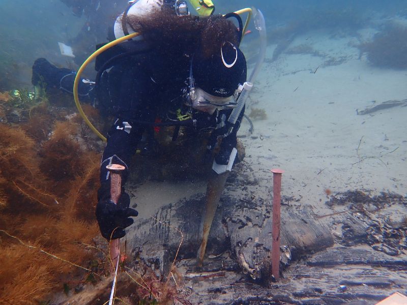
Irini Malliaros removes a timber sample from one of South Australian's ceiling planks. Some of the 'pink tubes' (copper-alloy bolts) that led to the shipwreck's discovery are visible in the foreground. Image Tim Zapor
The arrangement of the bow cant frames suggests a vessel with relatively fine lines. This reinforces the site’s identity as South Australian, given that Falmouth packets were typically designed for speed. The lower portion of the hull is double-planked and covered in copper-alloy sheathing, indicating that the vessel operated in tropical waters and underwent extensive refit and repair to prolong its use. Species identification of timber samples recovered from the wreck revealed the vessel was constructed mainly from white oak (Quercus robur); however, other samples yielded unusual or unexpected results. For example, the exterior layer of the double hull planking was Swiss pine (Pinus cembra), while some treenails were teak (Tectona grandis). Both species are atypical for early-19th-century British-built ships (which were almost exclusively constructed of white oak) and were probably used in later repairs to South Australian’s ageing hull.
A range of artefacts was observed, including intact glass bottles, glass and ceramic fragments, bricks, wooden barrel staves, gunflints and various copper–alloy and iron fastenings. The bottles and decorated ceramics all date to the early 19th century, and the bricks and barrel components could comprise whaling supplies that were stowed in the vessel’s lower hold and could not be salvaged. Taken together, the date range and types of artefacts in the assemblage all support the wreck’s identity as South Australian.
This early-19th-century ceramic mineral water bottle was one of the artefacts that helped confirm South Australian's identity. It was very likely manufactured in Germany, the world's largest producer of mineral water at the time. Image Irini Malliaros/Silentworld Foundation
In the wake of South Australian’s discovery, follow-up surveys and site inspections were carried out in May and July 2018, and again in June 2019. These visits revealed that sediment has steadily eroded from the site and uncovered extensive hull structure in the bow and midships areas. This has been beneficial in documenting the site, but has also exposed the wreck’s fragile timbers and artefacts to damage and destruction from natural processes, including marine borers, wave action and sediment scour. Previously buried portions of the port hull have progressively become more visible since April 2018, and a large seagrass-covered sediment mound that still protects much of the stern was observed to be eroding in June 2019.
The speed and extent to which these areas have been uncovered has alarmed our team and underscored the need for additional investigation of the wreck and the development of strategies to aid South Australian’s future management and protection. The team hosted a community meeting in Victor Harbor in December 2019 to announce our findings and gauge community support for conservation management options. These range from completely covering the site in sandbags to partial or complete archaeological excavation. Community consultation is ongoing, and we plan to revisit the site later this year to continue our investigations.
References
1 Logbook of the Barque South Australian (27 October – 21 December 1837), Entry for Friday, 8 December 1837. Royal Geographical Society of South Australia, MS 95c.
2 Although officially named Marquess of Salisbury, the vessel is listed in some archival sources – including Lloyd’s Register of Shipping – as Marquis of Salisbury. The variation in spelling is likely a common transcription error in which the French ‘Marquis’ was used in place of the English ‘Marquess’. Marquess of Salisbury was named for the 7th Earl of Salisbury, James Cecil, who was bestowed the title 1st Marquess of Salisbury in 1789. Cecil served as Joint Postmaster General from 1816 to 1823 and oversaw the Falmouth packet service during his tenure.
This article originally appeared in Signals 130
Discover more:
Watch Dr James Hunter talk about drafting an archaeological site plan of South Australian.
.jpg?h=167&la=en&mw=500&w=500 "Sketch of Port Bow Hull Structure and Foremast Step of the South Australian")
.jpg?w=278&hash=10357509EC93369D7D6CEA2461E5C567F6A49481)
Drafting an archaeological site plan of 'South Australian'
Read more