
RV Investigator at sea. Image: Ben Arthur, CSIRO/Marine National Facility.
Investigating Australia’s oceans
Commander Matthew Flinders and the crew of HMS Investigator spent three years circumnavigating Australia. From 1801-1803 a team of British sailors, soldiers, artists and scientists and an Aboriginal man, Bungaree, from the Guringai area around Broken Bay, just north of Sydney, charted the coastline and analysed marine and terrestrial flora and fauna. To support scientific observations the ship was outfitted with a greenhouse, microscopes, and a library. The cartographic and hydrographic work conducted by HMS Investigator stands as a meticulous record of the natural composition of our coastal nation and its surrounding waters.
215 years later, at the behest of the Australian public, CSIRO Marine National Facility (MNF) blue-water research vessel RV Investigator, is rewriting history as it pieces together the most complete modern map of our territorial waters. It is capable of hosting 40 scientists on sea voyages up to 60 days over a 10,000 nautical mile radius from the icy waters of Macquarie Island to the Coral Sea. A modern version of its historic predecessor, RV Investigator is outfitted with laboratory spaces, acoustics and scientific winches to accommodate all aspects of atmospheric, oceanographic, biological and geosciences research. Plus, onboard cameras beam back live images from its current voyage every 10 minutes.
Here at the museum, we also have a keen interest in exploring the oceans; scientific and environmental issues and actions as well as cultural understandings of the ocean sphere. I was part of the scientific staff on board the vessel for last week’s eight-day transit voyage (14-21 May 2018) from Brisbane to Hobart.

RV Investigator. Image: CSIRO/Marine National Facility.
Who are we? Why (and how) are we here?
To validate, to ground truth, to understand—need to make measurements in situ (Nittrouer 2017).
Australia claims maritime jurisdiction over 13.86 million km² of ocean waters. Collaboration between a number of federal and state government agencies, universities and non-government-organisations (NGOs) are required to conduct marine research within this vast estate. Scientific activities undertaken on board Investigator are the result of a grant program managed by the MNF that provides sea time to selected applicants. While not all applicants are successful, all efforts are made to ‘piggy back’ additional projects onto each voyage. Each chosen project is one that cannot be undertaken on shore. Scientists cannot test theories, answer questions, and find new life without the right boat and the right equipment. Within our extended marine territory, Investigator makes it all possible.
At sea, the vessel is managed by ship management company ASP with all crew the responsibility of the Ships Master. For this voyage, daily operations were the purview of the Voyage Manager Stephen Thomas, and all scientific activities are overseen by the Chief Scientist Dr Gustaaf Hallegraeff. CSIRO also runs an ‘Educator on Board’ program, allowing teachers from communities across Australia to apply for sea time and share the literal ups and downs of life on a research vessel with their students and others across the nation via live web crosses throughout the voyage. We also had on board Rhiannon Shine, ABC journalist, and a team from Wild Pacific Media, filming for the documentary, Australia's Ocean Odyssey: A Journey down the East Australian Current. All together, we are 57 people, most who have never met…at sea…together.
In fact, many of the words below were written sitting cross-legged on the aft main deck in the hope to share a brief glimpse into the joy of my journey at sea with these passionate scientists, crew and educators.

RV Investigator clearing the bridge as we left the Port of Brisbane on 14 May. Image: Emily Jateff/ANMM.
Plankton for the people
Our first scientific activity undertaken on the voyage was the deployment of the continuous plankton recorder (CPR) off the TRIPLEX A Frame on the stern. Everyone was SO EXCITED and gathered on the back deck with steel-capped boots and hard hats on, cameras in hand to watch a small grey box get unceremoniously plonked over the side.
The CPR is actually a fascinating bit of equipment. It was developed by Sir Alister Hardy in the 1930s. The initial design was so good that it wasn’t modified until the 1990s, when the Australian Antarctic Division rebuilt it in steel (instead of bronze) and rejigged the reload mechanism.
Within the CPR is a spool that collects plankton sandwiched between two sheets of silk 270 microns thick. At the end of the voyage, the CPR is recovered and the silk divided into sections with depth and location. Zooplankton and phytoplankton are visible on the silk when it is collected.

Spool of silk on the CPR showing zooplankton (orange) and phytoplankton (green). Image: Christie Evans.
It is towed in the deep water column off Investigator’s stern for 500 nautical miles. It is then recovered, the sink spool removed and replaced and redeployed for another 500 nautical miles. This was done twice throughout the voyage. The removed silk is cut into sections to be preserved and frozen for later analysis. Dr Ruth Eriksen, phytoplankton ecologist (CSIRO/IMOS) uses the recovered samples to study phytoplankton physiology, community dynamics and response to contaminants as part of the Australian Plankton Survey.

Dr Ruth Eriksen unloading the CPR in the lab. Image: Christie Evans.
Seawater is run continuously into the wet lab which gives scientists the opportunity to collect samples and analyse the dinoflagellates as we travel. The water is filtered through a silk sock and a one-litre sample collected every three hours throughout the voyage. Seawater samples are collected in a one-litre bottle labelled with time, date, location (latitude/longitude), water salinity and percentage of dissolved oxygen. These data are recovered from Investigator’s handy on-board Grafana, an internal web database available to all on board that displays the information collected by the vessel while underway.
I offered to collect a few of the mid-night samples. It seemed a bit rough that the same scientists who had to spend most of the voyage peering through the lens of a microscope on a pitching ship in an enclosed lab, also had to stay up all night to continuously collect samples. And what they were doing intrigued me.

GRAFANA showing ship-collected measurements available to researchers on board. A wealth of data is collected during each part of the voyage. Image: CSIRO/Marine National Facility.
Once collected, I shuffled the plankton-filled seawater sample to the Clean/Dry Lab where I put on protective hand and eyewear and added 1ML of Lugol to preserve the sample before placing in it the refrigerator (all the labs on Investigator are labelled – from Dirty/Wet, to Clean/Wet to Clean/Dry).
These samples contained thousands of different species of dinoflagellates. During the collection, they can be damaged and the addition of chemicals to preserve them can impact their health and appearance. Photographing them requires moving single dinoflagellate from onto a glass slide which can mean their form is compromised. Side note: I was moved to learn that a few of the scientists had purchased dinoflagellate jewellery for their wives.
TO HAVE FAITH IS TO HAVE WINGS (James Matthew Barrie, The Little White Bird)
Every day at dawn, Dr Eric Woehler (Birdlife Australia) and his student researchers clambered up to the Monkey Bridge (Deck 7) with binoculars, books and coffees in hand to record special and temporal variability of seabirds. Except for short meal breaks, they stayed on station until dusk. Dr Woehler predicted 40 different seabirds would be seen from the Queensland to the Tasmanian coast. The project, Spatial and temporal variability in the distribution and abundance of seabirds, collects data to indicate the presence or absence of bird species at sea to track migratory patterns and total count.

Dani Harmshaw searches for elusive shearwaters from the Monkey Bridge. Image: Emily Jateff/ANMM.
I have fond memories of birdwatching with my parents, so whenever I had a break in my schedule, I grabbed my copy of Birds of Australia and scurried up to the Monkey Bridge to see what all the fuss was about – and let’s face it, I also wanted to see a whale.
The seventh deck has a restricted rear view, so all identifications were taken within 90 degrees of the bridge and recorded by species, bearing and distance. Concerned by low numbers off southern coastal NSW, Dr Woehler, the chief scientist and voyage manager convened to correct the track of the vessel so as to pass through a cold core/warm core eddy system. Ocean circulation systems like these provide upwellings of nutrients to the ocean surface, increasing the probability of food on the surface to eat, this meant more birds!

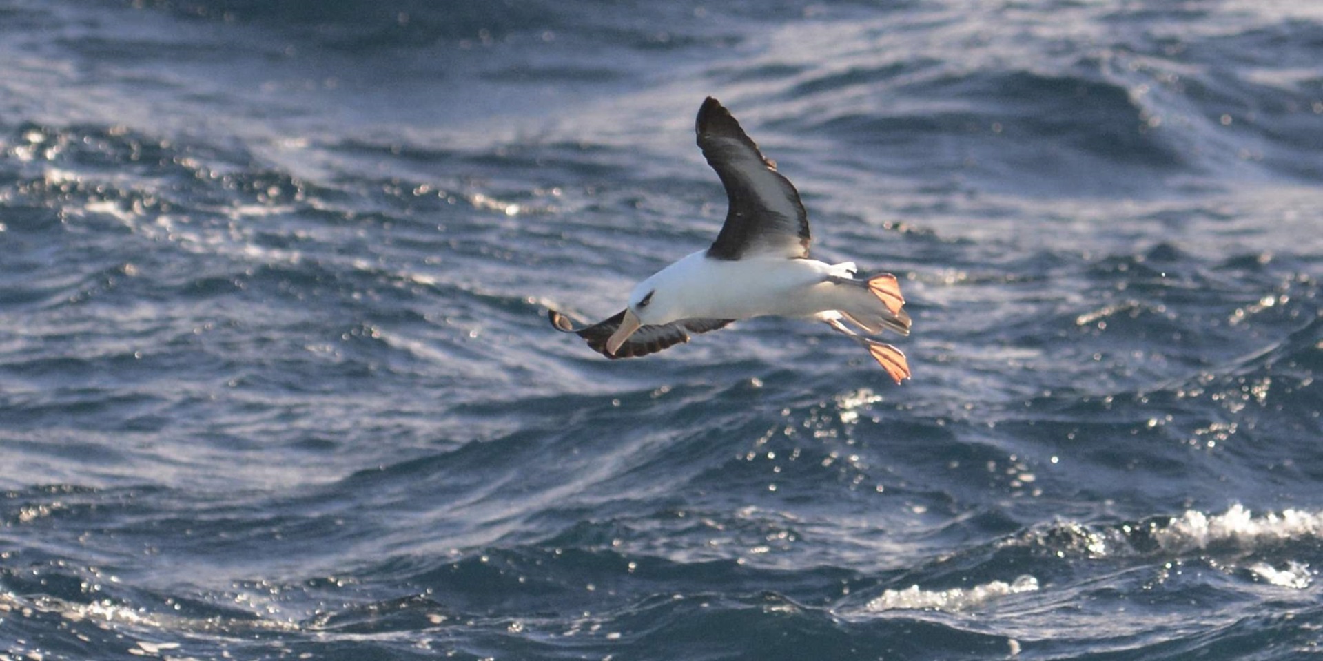
Shy Albatross, sighted off the Tasmanian coast. Image: Eric Woehler.
Primary identified species include prions, shearwaters, petrels and albatross. In total, 18,000 birds were identified during the voyage and recorded in the Investigator’s onboard database ‘Wildlife at sea’.
Zara King joined Dr Woehler’s project as a marine mammal researcher hoping to collect similar data on migratory patterns and surface behaviour of marine mammals. While the team was able to record a few large pods of dolphins, pilot whales (complete with two unidentifiable blows), it was early in the season for humpback whale spottings.
Remote-roam-ing
Onboard Investigator, we are always throwing things over the side, in the name of science, such the TRIAXUS, which was launched off the stern of the Investigator. It glides from 10m to 240m behind the ship collecting data on the condition of the ocean. Armed with sensors, cameras and probes this apparatus measures conductivity, temperature, depth, oxygen and chlorophyll and takes video. This data is used to interpret the condition of the ocean and its currents. Monitoring the chlorophyll in the ocean indicates the presence of life at the surface of the water which then, in turn, gives scientists an idea of biological health.
One of the most mathematically complex projects on board, it can be broken down as follows: CSIRO is working in partnership with the Royal Australian Navy (RAN) and the Bureau of Meteorology to develop an effective way of forecasting ocean currents (called Bluelink). Presently, satellite images give indications of ocean surface temperature but it is a sparse representation.
Readings from space are interrupted by clouds and so the temperature can be inaccurate in spots. By running TRIAXUS, accurate readings are taken both from the surface and deep below giving a more accurate representation of the ocean in terms of temperature and currents.

The museum’s Curator of Ocean Science and Technology, Emily Jateff with Lieutenant Commander Annalise Pearson, RAN, member of the REMOTE-ROAM team. Image: CSIRO/Marine National Facility.
All three Bluelink collaborators are interested in improving ocean forecasts to support defence applications. Lieutenant Commander Annalise Pearson, RAN oceanographer and meteorologist (METOC) says that the RAN take advantage of ocean currents to travel efficiently and successfully complete naval operations. For example, in areas of high nutrient cold water pushing upward there tends to be high concentrations of marine animals who create sound, interfering with the operation of the sonar systems. Forecasting areas of high and low-density currents they can use this to their advantage when using sonar.
Maintaining morale at sea
On day six of the voyage, we broke out the table tennis equipment. As sea voyages wear on, keeping crew morale up is an important factor to a successful mission. You must keep your hands and minds busy, both on and off watch. Investigator has lounges, movies, games and plenty of good conversation, but I can imagine that after 26 days at sea (the travel time to Macquarie Island and return), you may need a liiiittle bit of private time in your cabin. As noted in the voyage comment book: “Couldn’t find spa and shuffleboard deck. Plz mark on ship’s map. Thanks!” Anon., 27/11/15.
I thought that on a ship of this size that we’d all be neatly compartmentalised into our various areas and never the twain shall meet, but on Investigator, that is (thankfully) not the case.
From the first step on board, I was approached by people wondering who I was and what I was there to do. Crew, support staff and scientists were kind, professional and happy to answer questions, direct you to the nearest correct stairway (it’s a bit of a maze at first), share data, and have a chat over the evening meal.

An example of our dinner menu. Amazing, right? Image: Emily Jateff/ANMM.
Meal times became one of the highlights of the voyage. It’s amazing how quickly your stomach gets used to lunch at 11:30 and dinner promptly at 17:00. With the fare on offer from the chefs and caterers (rib eye, chicken Kiev, sticky date pudding), and a great steward, it’s no wonder that all on board were sad to contemplate making their own meals once back on solid ground. It is true that full stomachs and a collaborative atmosphere inspire great science at sea.
Delving into the natural archive
Sunrise on the seventh day of an eight-day voyage at sea. The 6000 tonne RV Investigator uses Dynamic Positioning (DP) to hold a position within +/- one meter of variability due south of Maria Island. This point, carefully selected by onboard geologists after hours of bathymetric mapping, is identified as that most likely to have a soft sediment bottom. Sediment dynamics are recorded by ship-deployed instruments that operate within the water column or on the seabed.

Mech-tech Damian Pretyman with the results of the first core. Not good, we hit a shell and rock bottom instead of sediment. Image: Emily Jateff/ANMM.
The presence of soft sediments means that the gravity corer can penetrate through and collect a tubular stratified sample, or ‘core’ of the subbottom sediment. A single core from this region can contain coastal deposits up to 2000 years old. Our first core, taken three days ago off Port Hacking, NSW, was a bust, recovering only a handful of shell and rock. Today’s cores at Maria Island are our last chance for another sample.

The TRIPLEX A FRAME, after deployment of the multicorer. Image: Emily Jateff/ANMM.
As dawn breaks over the back deck, there are grim looks on the faces of the scientific team who were tasked with sectioning out and analysing the cores. If we can’t recover any useable cores, two years of planning are all for naught. But Investigator has a crack team of mechanical engineers and seasoned deck crew who deploy the 12-tube multicorer off the TRIPLEX A Frame on the back deck and the long, round barrelled gravity corer off the side winch multiple times in quick succession at locations north and south of Maria Island, recovering multiple cores for both sites. So there were well-earned high-fives and smiles all around.
If you hope to enjoy a prawn-studded spaghetti gamberi in future, today’s cores may be the only thing between you and death. In recent years, shellfish from Tasmanian waters have sporadically created, via cystic growths, a toxic algal (Alexandrium dinoflagellate) bloom that interferes with the synaptic connection between nerve endings in some mammalian species, causing paralysis and death. This bloom led to a global shellfish recall in 2012 and 2015 and crippled the shellfish industry in Tasmania. This project, led by Chief Scientist Professor Gustaaf Hallegraef, is the reason we are all here.

An example of what the Itrax core scanner can do: This is a core from a New Zealand lake and contains material which spans 2000 years. On the left is the high-resolution optical image while the x-ray image is on the right. Dark objects in the x-ray are dense objects. In this core they are stones. This tells us the concentration of all elements heavier than magnesium in the core, in great detail. It can take measurements every 200 microns. Find out more at ANSTO Itrax and here. Image courtesy Craig Woodward/ANSTO.
Sediment cores – and the Ancient DNA record, or fossilised dinoflagellates encased within localised contexts (layers of mud as stratified layers of time) – assist in the identification of a climate-derived baseline for toxin manifestation and shellfish responses to these conditions. The extracted cores include sediments up which are up to 2000-years old and the results will provide information on past algal blooms, to help with predicting future blooms and support an economically viable shellfish industry for Tasmania.
More venturesome voyages ahead for Investigator
Tomorrow hard earth replaces the rock and roll of the decks beneath my feet. For RV Investigator and its seasoned crew, this trip is a breeze, a short run along the coast from Brisbane to Hobart. For me, as one of 37 scientists, support staff, students, media and educators selected to participate in the second transit of the 2018 season, it is much more: The voyage on Investigator was an opportunity to observe Investigator at sea and brainstorm opportunities for collaboration and sharing ocean science stories.
In 2014, the newly-built RV Investigator arrived at its home berth in Hobart, after travelling from its construction site in Singapore. Three years later, just like the original Investigator, it had completed its first circumnavigation of the continent. The great thing about this vessel is that this circumnavigation won’t be its last. RV Investigator will continue to provide a home to scientists as it searches the seas for answers to questions about the ocean space, life within it, and its effect on our future.
It’s been a couple years since I was last on a ship of this size and I was quickly reminded how much I love it. Going to sea is something everyone should try at least once. That week, the Australian Government announced that it would increase funding for the vessel up to 300 days at sea (it currently operates on average 180 days at sea). I heartily recommend to those considering it, to put in an application for an upcoming sea voyage on board the RV Investigator — I’ll race you there!

Sunset aboard the RV Investigator. Image: Eric Woehler
— Emily Jateff, Curator of Ocean Science and Technology, with contributions from Kristie Evans, On Board Educator, STEM Educator at Seaview Downs Primary.
References
- Challenges of Observational Oceanography in the Modern Coastal Ocean, 2017 Nittrouer, Charles Oceanography 30(3): 71