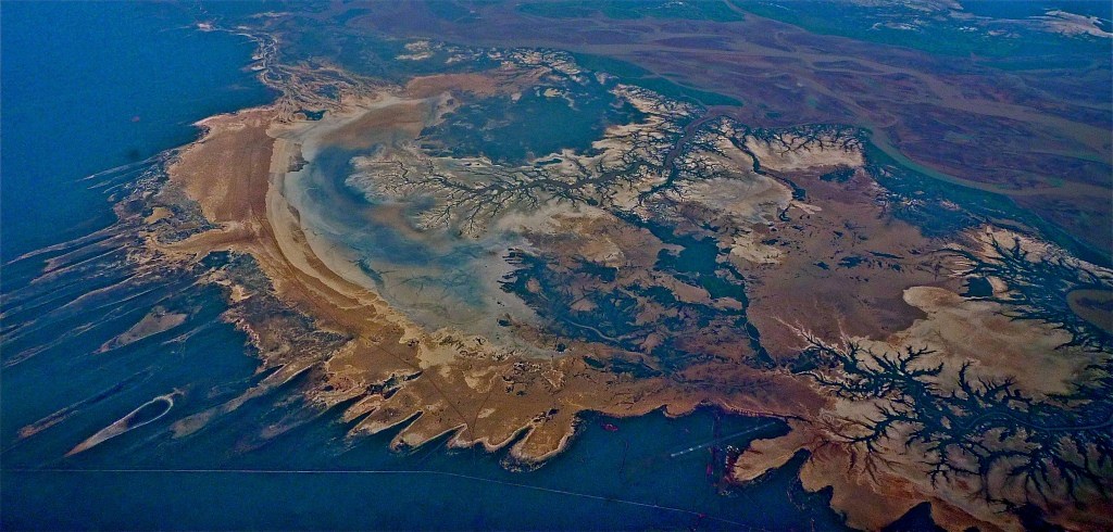
If you have a minute, take a look at this shot with me. It’s a maritime scene – and not a cross between a really bad accident on the Persian rug or a promising entry for the Sulman Prize! It’s been cropped a bit and I’ve fiddled the contrast and colours to give it more impact, but the rest is what the camera and I saw.

5 pm 13 July. Photographer D Payne
This was taken in mid July, 35000 feet up, window seat 41K in a Boeing 777, three hours or so from Singapore, on the way home from holidays, with pleasant memories of European landscapes recorded in 300 or so snaps of idyllic scenery, all as promised in the travel brochures. But no one mentioned this scene, and it seems to top them all. What’s going on down there?
Looking down, the only way to make sense of this abstraction was to look things up. A scan through Google Earth gave a precise location – West Australia, the mouth of the Fitzroy River at the bottom of King Sound on the edge of the Kimberley’s. Mankind has already established itself, people have walked, camped, fished and paddled craft on this coastline for over 40,000 years. My research shows that its home for the Nyikina, one of a number of Indigenous communities in this area.
As a marine environment it’s particularly noteworthy as the home of the highest tides in Australia, over 11 metres span at its best, and the tentacles looking like a dissection of a living organ with arteries and veins are just that- the flow of water in and out of the thriving and alive marshland- I’ve been lucky it seems and caught this at prime time to outline the flow that’s the lifeblood of the shallow basin. Muddy browns give way to opaque blues and greens as the river swells toward the sea; red, brown clay and sandy soils, green for the growth hugging the water edge. Waves of movement from the easterly wind and monsoonal rains seem visible in the patterns of land and vegitation – the tussles between erosion and the growth reclaiming its ground can all be read from up here.
It’s called pindan country, a term from the local Indigenous language that was first mentioned in print in August 1884 in the Perth Enquirer. Pindan refers to the soils and savannah vegetation that includes a base of grasslands, mid-height wattle shrubs and patches of higher eucalypts and the famous boab or bottle trees. Within this is the tidal marshland, spilling out to the south of Derby, which lies on a slightly elevated piece of land at the bottom of the sound.
A closer look shows that the wilderness we see from above still has the telltale straight lines of modern man – roads, tracks, and down at the lower right is the give-away cross-over pattern of Derby airport’s runways. Compared to the contrasting features of the natural landscape, they are just scratches on the surface, spoiling marks that are almost waiting to be covered up.
David Payne curator ARHV