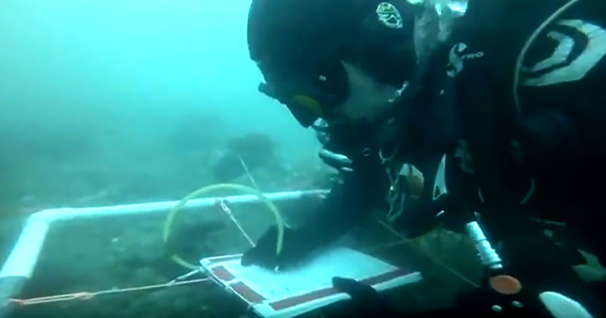

James Hunter uses a mapping grid to sketch artefacts and features on the ‘Caroline Site’ during RIMAP’s 2017 field investigations. Image: Greg DeAscentis/© RIMAP 2017.
This past September, Kieran Hosty and I travelled to Newport, Rhode Island to assist an ongoing effort to archaeologically document eighteenth-century shipwreck sites in the city’s harbour associated with the American War of Independence (1775-1783). We were invited to Newport by Dr Kathy Abbass, Director of the Rhode Island Marine Archaeology Project (RIMAP), an all-volunteer organisation that has been locating, documenting and investigating the maritime cultural heritage of Newport Harbor and its adjacent waterways since the late 1990s. Maritime archaeologists affiliated with the museum have been working with RIMAP since 1999, and a team comprising Kieran Hosty and the museum’s Head of Research, Dr Nigel Erskine, visited Newport as recently as September of last year to assist with the project.
Our interest in RIMAP’s research stems from the investigation of a fleet of British transports scuttled at Newport during the Battle of Rhode Island in August 1778— a story that has already been chronicled in a previous blog by Kieran and an article by Nigel in the scholarly journal The Great Circle. Among these vessels was the Lord Sandwich, a 368-ton bark that attained international recognition under its previous name, HMB Endeavour. Endeavour, of course, is best known for its voyage of exploration between 1768 and 1771 under the command of Lieutenant James Cook, during which it became the first European vessel to reach Australia’s east coast.
Clues to Endeavour found in 2016
As the 2016 field season was coming to a close, Nigel and RIMAP volunteers John and Caroline Cassese were tasked with searching an area of seabed to locate a target of interest detected during a prior sonar survey of the harbour. The anomaly was located within the study area where Lord Sandwich is believed to have been scuttled, and in relatively close proximity to RI 2394 (dubbed the ‘Kerry Site’), one of four eighteenth-century shipwrecks discovered and documented by RIMAP during previous expeditions.

Scaled map of the ‘Kerry Site’, one of the candidates for the shipwreck of Lord Sandwich/ex-Endeavour. Image courtesy RIMAP
After a brief search, Caroline encountered a pile of stone; closer inspection revealed a couple of fragments of coarse earthenware ceramic nestled among some of them. The pottery fragments were documented in situ (in place) and later recovered for identification and analysis. Discovery of artefacts in association with the stone pile was significant, given that four shipwrecks were already confirmed within the area where five transports are known to have been scuttled, and the whereabouts of the fifth vessel had until that point remained elusive. The very real possibility that the stone pile of RI 2794 —now dubbed the ‘Caroline Site’—represented ship’s ballast and the remnants of a shipwreck prompted Kathy to make it the focus of the 2017 investigations.
Hurricanes Irma, Harvey and Jose impact the fieldwork
Kieran and I arrived in Houston, Texas on the afternoon of 9 September, just as Hurricane Irma was bearing down on the Florida Keys. Irma made landfall as a Category 4 storm with peak winds of 185 mph (295 kilometres per hour), was the strongest Atlantic storm outside of the Gulf of Mexico or Caribbean Sea on record, and resulted in at least 134 deaths. It came on the heels of Hurricane Harvey, a devastating Category 4 storm that had struck Texas only two weeks prior and resulted in 90 deaths, as well as the highest-ever recorded rainfall total (1,640 millimetres) for any tropical cyclone to directly affect the United States. Although trivial in the grand scheme of things, we were thankful that our connecting flight to Boston that evening was not disrupted. The odds, however, were not entirely in our favour: The 2017 Atlantic hurricane season was far from finished wreaking havoc in the Caribbean and along the American coastline, and would ultimately prove disruptive to our work in Rhode Island.
After an overland drive from Boston the following morning, Kieran and I joined Kathy and RIMAP field supervisor Dr Kerry Lynch in Warren, Rhode Island, where new volunteers underwent a two-day training course in maritime archaeological theory and methods. We assisted with the site mapping exercise, and then continued on to Newport and moved into our accommodation. Work began in earnest on the morning of 11 September, and involved shifting equipment aboard the project’s primary dive platform, M/V Norlantic Diver and making final preparations before fieldwork commenced. First among many tasks was the installation of a system of mooring buoys within the study area. A series of buoys marked the general location of each known and potential shipwreck site, and enabled Norlantic Diver to be moored over a site rather than anchored (which could inadvertently result in site damage). An associated network of down-lines allowed divers safe, direct site access. With these in place, the team conducted an inspection of the Kerry Site and two other shipwrecks in the study area (the ‘Kathy’ (RI 2578) and Rod (RI 2393) sites) and confirmed that none had been disturbed since 2016.

Location of shipwreck sites that may represent scuttled 1778 transports, including Lord Sandwich/ex-Endeavour. Image courtesy RIMAP.
We then set to work delineating the Caroline Site’s boundaries and installing a physical grid over its visible components. During the 2016 investigations, Nigel and the RIMAP team surveyed the area immediately surrounding the visible stone, but were unable to complete their inspection before the field season ended. As a consequence, one of my first tasks was to search the seabed for additional artefacts and stone in a zone southwest of a temporary site datum installed as last year’s fieldwork concluded.
This was easier said than done, as the visibility in Newport Harbor during the summer and fall months tends to be less than two metres. To complicate matters, the seabed is predominantly silt and/or silty sand that is easily disturbed and can reduce visibility to zero in moments. The water also tends to be chilly, even when the air temperature is warm. On a typical dive, the mercury hovered between 18 and 19 degrees Celsius, and occasionally dipped even lower due to thermoclines. Despite these conditions, I quickly located the old datum and, after conducting a thorough search, installed a new one and increased the site perimeter to encompass additional finds.

One of the Caroline Site’s residents looks on as James Hunter maps a portion of the seabed. Image: Greg DeAscentis/© RIMAP 2017.
Drawing grids
The grid system installed over the site was approximately 80 square feet (24.4 metres) overall, and sub-divided into individual grid squares (or ‘units’) that measured three feet (0.91 metres) square. Visible components such as the concentration of stone comprised only a small portion of the delineated site, but this was intentional. By expanding the perimeter around visible artefacts and features, the team created a ‘buffer zone’ to ensure that any buried site components are included within the same grid framework in the event they are exposed—either through controlled excavation or natural processes—at some point in the future. For the sake of economy and ease of assembly and disassembly, and to ensure it would have a bit of ‘give’ in the event it was inadvertently snagged by anchors, trawls or fishing lines, the grid framework was created from brightly-coloured string attached to concrete Besser Blocks (or ‘cinder blocks’ as they are known in the U.S.).
Installation of the grid progressed rapidly, but an unforeseen and totally insurmountable obstacle loomed just as it was nearing completion. Hurricane Jose, which narrowly passed the Leeward Islands as a powerful Category 4 storm on 9 September, subsequently moved north and meandered off the U.S. Eastern Seaboard, where it lost strength. However, the system suddenly re-intensified on 19 September and again moved northward. Within two days, it was again meandering, this time just south of Rhode Island. Although officially classed as a ‘post-tropical cyclone’, Jose still generated winds in excess of 50 miles per hour (80.5 kilometres per hour). These in turn created short, choppy seas within Newport Harbor that at times exceeded two metres and made boat and dive operations extremely hazardous. As a result, the project was curtailed for nearly a week while Jose’s remnants slowly moved eastwards and gradually dissipated. In an ironic and unfortunate twist, Kieran—who had prior commitments back in Australia—departed for Sydney as the weather in Rhode Island finally began to settle down.
With Jose gone, fine conditions returned to Newport and the team was able to resume work. The grid suffered minor displacement from the storm, and visibility was somewhat diminished, but installation of the last grid lines was completed in an afternoon. At that point, a comprehensive regime of site mapping commenced, with each team member assigned to sketch ‘lanes’ of consecutive grid squares. My lanes were positioned in the approximate centre of the site, and I moved along each from south to north, systematically documenting the contents of the grid squares they contained.
This was facilitated by a portable three-foot square mapping grid. Manufactured from an outer frame of PVC piping, and divided by string into smaller one-foot (0.30-metre) sub-sections, the mapping grid was placed atop the area to be documented. Each team member carried a series of underwater slates, attached to which were pre-printed forms on Mylar (plastic drafting film) featuring the outline of a blank mapping grid. The PVC mapping grid’s sub-sections divided the area to be documented into more manageable portions, and its strings served as guides that allowed team members to sketch the grid’s contents at a smaller scale on the pro formas.

James Hunter uses a mapping grid to sketch artefacts and features on the ‘Caroline Site’ during RIMAP’s 2017 field investigations. Image: Greg DeAscentis/© RIMAP 2017.
Mapping progressed quickly, and was completed within four days. The predominant feature noted throughout the site was stone, with a limited number of artefacts widely interspersed within the main pile. Very large stones—appearing both in isolation and in small clusters—were noted to the south and west of the main pile, and appear to be elements of a natural geological formation that has eroded out of the seabed. Among the historic artefacts recording during the mapping project were earthenware ceramic sherds (similar to those documented and recovered in 2016), glass bottle fragments, and remnants of at least one leather shoe. Isolated modern objects, including lobster pots, aluminium beer cans, and what appears to be foul-weather gear, were also observed on the site. All of these items were dutifully recorded, and will assist in the site’s overall analysis and interpretation.
Photographic and video survey
Once mapping was completed, the team embarked upon a systematic photo and video survey of the visible site. This was done with the goal of creating a full photomosaic, as well as generating a photographic record of each grid square that could be used as a visual reference during development of the overall site plan. Because of my prior experience capturing imagery for 3D digital photomosaics (see: Meanderings in the murk and A ringing success), I was one of a group tasked with shooting comprehensive photographic and video footage of the site. Working in conjunction with RIMAP volunteers Greg DeAscentis, Carol Hottenrott and Andy Elvin, I swam multiple north-south transects, doing my best to maintain a consistent height above the seabed and keep the perimeter of each grid square in my camera’s frame as I slowly passed overhead. Unfortunately, water clarity was less than desirable—averaging one metre or less—during the survey, and it remains to be seen whether a useful photomosaic can be generated from the imagery Greg, Carol, Andy and I obtained.

James Hunter (left) confers with Kerry Lynch and Andy Elvin aboard Norlantic Diver following a dive on the Caroline Site. Image: Greg DeAscentis/© RIMAP 2017.
My time with the project was now drawing to a close, and I spent my last day of fieldwork searching an unexplored area of seabed adjacent to the Caroline Site. Kerry, Carol, Andy and I established a new baseline that extended 300 feet (91.4 metres) north of the Caroline Site’s northwest corner. The four of us then swam transects and gradually moved east away from the baseline. Although I had hoped to find a new shipwreck, it was not to be: The seabed was a predominantly flat and featureless blanket of silt, save for scattered mussel shells, a couple of very large (geologic) stones, and a broken lobster pot. While this outcome may seem discouraging, it really isn’t. The size of the area that remains to be searched is considerable, and there is every chance that a previously-undocumented shipwreck site may yet still turn up. On 29 September—my final day on the project—I remained topside and took part in a live-streaming video event that included interviews with RIMAP team members (myself included), and real-time underwater footage of Kerry and Greg working on the Caroline Site. Afterwards, I was interviewed by local television news affiliate ABC-TV Channel 6. That evening, RIMAP hosted a dinner for the team and gave me a proper send-off for my long journey back to Australia!

James Hunter preparing to dive on the Caroline Site. Image: Greg DeAscentis/© RIMAP 2017.
The search for Endeavour continues
Due to unseasonably mild weather in October, RIMAP volunteers were able to mount one last search of the new survey zone, but did not encounter anything of note. The team closed out the 2017 field season by recovering the grid system and mapping equipment from the Caroline Site. With winter setting in, RIMAP will most likely have to wait until the spring and summer of 2018 to resume searching the unexplored survey areas. In the meantime, a short documentary film is being produced that summarises the progress that has so far been made in the search for Lord Sandwich, and is expected to be completed by January. The film will be available on RIMAP’s website and will also appear on the museum’s website and social media platforms.
Kathy has extended an invitation to the museum’s maritime archaeology team to participate in the 2018 investigations, and we look forward to being involved and finally pinpointing the wreck of Lord Sandwich (ex-Endeavour)!
— Dr. James Hunter, Curator RAN Maritime Archaeology
In addition to those mentioned above, the 2017 field team included Steve Bastien, Bill Burns, Elliott Caldwell, Ben Cassese, Caroline Cassese, John Cassese, Grayson DeAscentis, Saliou Ibrahim Fall, and Gwenn Stearn, as well as a legion of people who helped from ashore. All were instrumental to the successful completion of this year’s work, and deserve thanks and acknowledgement for their invaluable assistance.